Toll plaza on NH7.
From there you need to take a left after the toll plaza, and not go straight up a flyover. The flyover takes you down to Salem. So, you take a left, on to NH46 (Wikipedia page), and after a couple of kilometers you take a right, which puts you on to NH66 (Wikipedia page).
This is where NH46 and NH7 meet. So, coming from Bangalore, you stay in the left lane, and make a left at the intersection, below the flyover.
View Larger Map- this is where NH7 and NH46 intersect.
After that, you go for about a kilometer or two on NH46, and then make a right, which puts you on NH66.
View Larger Map
Somewhere on NH66.
This is the highway that takes you all the way to Pondicherry. This highway is two-laned, undivided all the way to Pondicherry. The first 40-60 kms are not that great, but if you keep your eyes peeled for potholes, you could do 60kmph. Not too good, but not too bad either. And the road is not that bad. It is disappointing after having experienced the Golden Quadrilateral on NH7 and NH46. After that you can do 80kph for most of the remaining stretch. After Tindivanam, there is work going on to upgrade the highway to a four-laned highway, but it looks like the four laning will be completed only in the next three to four years.Just checked on the net, and per the NHAI site, the NHAI:.Completed Stretches on Golden Quadrilateral page states that the 170km stretch between Krishnagiri and Tindivanam is yet to be awarded. This stretch does not seem to have too much traffic on it, so it is a moot point whether contractors will come forward to upgrade this stretch, especially if the project cost is to be recovered via a tolls.Unless the government steps in and meets the viability gap...

It is likely that NH66 will stay two laned between Krishnagiri and Tindivanam for the next several years. The highway does not see much traffic anyway, so maybe regular maintenance of the road should suffice. What is striking however is that there are absolute no decent restaurants on the entire stretch. The Adiyar Anand Bhavan and a Cafe Coffee Day at Shoolagiri is the last stop where you can fuel up your stomach for the long drive ahead. People traveling between Bangalore and Mysore have been spoiled for choice, with Lokaruchi Kamat, Cafe Coffee Days, Baristas, and even a McDonald's on the 100km SH 17.


Another welcome fact to be noted is that there are almost no speedbreakers on this entire stretch. And speed-breakers are in India by definition unmarked, and with no signs warning the driver to their presence. Drivers then rely on the undulations and the slowing of the speed and the brake lights coming on on the vehicles in front of them to figure out that there is a venerable speed-breaker up ahead. Unless you happen to be the lead car. In which case your vehicle has to provide the undulations and all.
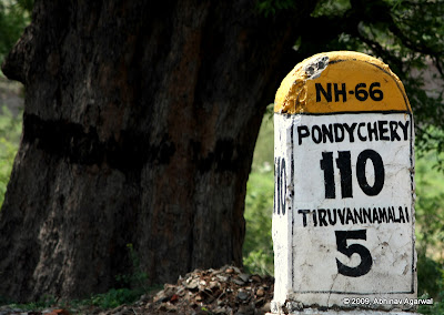
The mileposts all have the distance to Pondicherry mentioned, and below that the distance to the next big town. For most of the way it is Tiruvanamalai.

The town of Thiruvannaamalai is famous for the Arunachala temple, dedicated to Lord Shiva. It is marked by four massive gopurams; and when I say massive, they are huge. More than two hundred feet high.
What is baffling is that the highway, all two lanes of it, runs right by the temple boundary. Yes. See for yourself. This below is NH66.


A closeup of the west-facing gopuram.
The photos of the gopuram are of the one on the left in the map below.View Larger Map
A short drive after Tindivanam is the Gingee fort. Now, this has to be one of the most deceptive looking forts I have ever seen. From afar it looks like someone piled small and big rocks upon each other to build a hillock. And you cannot make out the contours of a fort from afar. It is when you park outside the entrance and take a closer look that you realize that there are actually steps to take you to the top of the fort, at a height of 800 feet. It looks like a good hour's trek up, and not advised in the scorching Sun. Best attempted early in the morning.


On the way back from Chennai, you travel on NH46, which is by far the best highway I have driven so far in India. The entire stretch has been four-laned, roads where you can do 100kmph comfortably, and if adventurous enough, can also do 120-140kmph. High speeds are however inadvisable.
In some stretches the highway is six lanes wide. As it passes through small towns, there are flyovers built over the city road intersections, so that you do not come across any traffic signal. The highway is not access controlled, but this is a huge step forward nonetheless. There are toll plazas every 40-50 kms or so, and you pay Rs 25, 35, or 45. Well worth it.

The drive is very scenic in places, with the hills rolling by gently, and the highway making its way. The divided highway, and the comfort in the knowledge that there are no speed-breakers or any unexpected potholes lets you take in the scenery.
These two photos below are somewhere 25 kms east of Krishnagiri.
Onto Pondicherry in the next post.
© 2009, Abhinav Agarwal. All rights reserved.


